[OPTIMAL] - Introduction

OPtimal Transport for Identifying Marauder Activities on LiDAR (OPTIMAL)
Machine Learning for the automated detection of looting activities in archaeological areas on LiDAR points clouds time series

[OPTIMAL] - Gallery

[OPTIMAL] - Tab


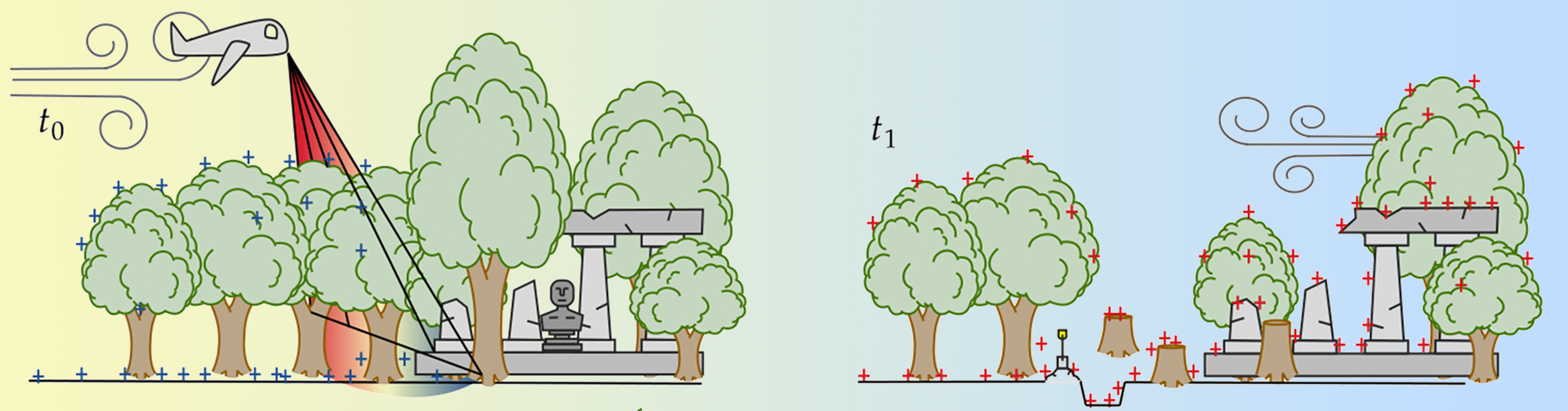
Illegal excavations of archaeological sites to collect historical objects ("looting") are a pressing issue on a global scale. The general upsurge of pillaging activities in cultural heritage sites and the subsequent trafficking of the plundered antiquities call for the timely development of techniques for the automatic identification of looting through the detection of features associated with illegal excavations.

Remote sensing is the most efficient approach to identifying the marks left on the terrain by looting activities, which are undertaken with different methods and rates (e.g., by hand or mechanical support, systematically or casually, etc.). The recognition of looting patterns is mainly performed on Earth Observation (EO) data (e.g., from synthetic aperture radars) but such application is relatively limited. Although EO data can be effectively used for monitoring looting in critical areas (e.g., conflict zones and deserts), they are not suited for areas with thick vegetation coverage.

Airborne LiDAR is instead the best single remote sensing method for penetrating landscapes covered by continuous vegetation. Its unique ability to record 3D topography with a high degree of accuracy (typically, 10–15 cm in both plan and height) provides the opportunity to assess looters’ damages by detecting the depth of looting pits.

The OPTIMAL MSCA-IF project, financed by the European Commission's Horizon 2020 Work Programme aims to develop an efficient Machine Learning (ML) approach, based on optimal transport, to automatically detect looting (past and present) on airborne LiDAR point cloud time series. OPTIMAL proposes for the first time the use of LiDAR specifically for monitoring and assessing the damages of looting.


OPTIMAL project will introduce a novel ML tool, based on optimal transport, to automatically identify looting activities, which will allow for wide spatial contexts to be swiftly and accurately analysed. The key steps of the research methodology are detailed below.

1. Create the first multi-temporal LiDAR dataset to train change-detection methods for the identification of looting activities, which will be released to the scientific community to serve as a benchmark for looting detection.

2. Design of a change-detection algorithm on complex and time-evolving LiDAR point clouds via ML approach, OPT, based on optimal transport. The optimal transport theory provides a natural way to detect changes between pairs of point clouds allowing to compute the geometric discrepancy between two distributions (the pair of point clouds). The design and the implementation of this approach will be performed at the Kyoto University (Third Country host institution) under the supervision of Prof Makoto Yamada.

3. Evaluation of the effectiveness of the OPT approach using both image-based manual inspection and fieldwork activities. To validate the accuracy of the predictions, the areas of interest will be visually inspected on screen for signs of looting by the CCHT archaeologists, led by Dr Arianna Traviglia, using available High Resolution (HR) satellite imagery. For a limited number of sites, a direct check on the ground will be performed through the support of a number of CCHT archaeologists and external collaborators that have committed to undertaking targeted surveys.


Results & Dissemination

Papers

Talks


Arrived in Kyoto! 

[28/05/2022]

MC Fellow Dr Marco Fiorucci has finally landed in Kyoto where he will work on his MSC project,    OPTIMAL, under the supervision of Prof. Makoto Yamada, PI of the High-Dimensional Statistical    Modelling Team at Kyoto University.

Marco will explore a new effective methodology for the automatic detection of looting activities.  He will design a change-detection algorithm on complex and time-evolving LiDAR point clouds via a machine learning approach, based on optimal transport (OPT)


TRAIL 2022

[27/04/2022]

With CCHT Coordinator Dr Arianna Traviglia, MC Fellow Dr Marco Fiorucci travelled to Postojna, Slovenia, to take part in TRAIL 2022 - Training and Research in the Archaeological Interpretation of Lidar. 

Lectures and training sessions focused on the use of LiDAR data and machine learning will provide Marco with useful insight to better address his research questions in the field of landscape archaeology.

Marco will also have the opportunity to discuss with Dr Damian Evans the detection of looting activities occurring in Cambodia.


OPTIMAL project takes off!

[16/01/2022]

Dr Marco Fiorucci has officially started his Marie Skłodowska-Curie project: OPTIMAL

Keep following the news about his research activity and the project's progress! 


MSCA Research Fellow

Marco Fiorucci, PhD


Supervisors:


Arianna Traviglia, PhD (CCHT Coordinator)


Makoto Yamada, PhD (Kyoto University Associate Professor)


Affiliated Researchers: 


Riccardo Giovanelli, PhD Student


Paolo Soleni, IT Technician


[OPTIMAL] - Acknowledgments